Canoeing one man’s backyard. -from Paddler Magazine, April 1998
Too busy watching waterfalls spilling from the cliffs along Reisafjorden, I looked up as our car abruptly slowed for sheep meandering down the center of the road. Welcome to North Norway, where the government protects the rights of sheep on local roads.
Snow clung to the 1,000-foot walls of the fjord, and our first glimpse of the Reisa River showed a narrow, bouncing waterway reminiscent of spring runoff in New England. Only it was early July, and the deep green water still looked icy cold.
Alv Elvestad of Enfield, New Hampshire, had invited seven American paddlers to journey to his homeland and travel three rivers in Finland and Norway above the Arctic Circle. We were beginning the trip in the backyard of his family’s old homestead in the tiny village of Sappen, where the river lapped at the pasture behind the 19th-century house.
Already I liked the feeling of completeness to this “circle” trip. We would organize at the farmhouse and then drive across the border into Finland to fly into the Lataseno River, right near the start of the 240-kilometer Arctic Sea Kayak Race which has attracted American competitors in the past. We would travel East along the Kautokeino River and North down the Reisa – returning to Alv’s backyard. Essentially we would end up at the beautiful Reisafjorden, the inlet leading to the Barents Sea, which I was enjoying when I wasn’t distracted by our slalom through the sheep in the road.
There is no better way to see a country than through the hospitality of local people, and I loved the openness with which Alv and his family greeted our group. Of course, it doesn’t hurt when the hosts ply you with regional specialties at every meal, I mused, as I tucked into thick cod steaks with the characteristic little golden potatoes of the Norwegian north. Every family seems to maintain a little patch outside their back door amid a profusion of colorful flowers that bloom in the midnight sun.
By the time Alv’s parents, Einar and Sofie had served us cloudberry cake, made with plump and prized golden berries found only in the north, I was ready to adopt the Norwegian way. Or perhaps it was the heady brew of lingonberry (mountain cranberry) tea laced with brandy that materialized mid-trip.
“Lingon?” said Alv, raising one eyebrow slightly, when I rhapsodized about the tea. “In Norway we call it tyttebaer, but we’ll let it slide.” Oops, I thought, I’ve used the Swedish word. I had revealed my connection to my Swedish mother-in-law and my husband Bruce Lindwall, both of whom are fond of this tasty northern cranberry served at special dinners at home.
Canoeing in north Norway is a trip back in time – culturally as well as geologically. The Germans occupied this region during World War II, and as an American born in the boom after the war, I gained a better understanding of its impact through the stories of the Elvestad family. Initially, the Germans built sawmills to strip the valley forests of their pine, and they provided employment and relief from poverty for many local residents working with Slavic and Russian prisoners of war and German convicts to harvest the timber.
But devastation struck the area in 1944, when the Germans burned buildings and slaughtered animals in an attempt to leave no resources when the Russian front advanced into the north. Most families lost their homes and belongings as German soldiers torched the region. Fortunately for the Elvestads and their boating-friendly backyard, their home was one of only three buildings left standing in the valley after its use as a German headquarters. A lovely place now used as a summer home, it features a boarding ell that dates to 1820 when it was used as a school.
Despite its location just north of the 69th latitude (similar to Siberia, Greenland and the Brooks Range in Alaska), this green valley is much lusher than any Arctic region I’ve ever seen in the U.S. or Canada. Fields of yellow globeflower and red campion dance in the wind, thick birch groves flank the river, and vegetable gardens thrive during the short growing season because of 24 hours of daylight.
With its climate tempered by the Gulf Stream, the coast has long encouraged farming, fishing and hunting, whether it was the Sami reindeer herders prior to the 1600s, or Finns in search of arable land in the 1700s. In fact, this region known as Finnmark has the longest ice-free coast of any Arctic region in the world, and its 60,000 lakes and thousands of kilometers of trout and salmon rivers continue to lure outsiders like us.
The last ice age pounded the Reisa into a U-shaped valley as it nears the sea, and the gravel left by the glaciers is evident to canoeists as we wind easily along miles of gravel bars. The character of the upper river is completely different – wild and remote. The river drops 1200 feet over 60 miles from the interior Sami plateau, much of it in the spectacular upper canyons, and our group felt as if we might literally drop off the edge of the earth as we approached the first canyon.
The Sami plateau is an open, windswept plain much like the tundra of northern Canada – no trees, just gray alder bushes dwarfed by the wind. Patches of snow still covered the surrounding mountains since the raw weather had been unrelenting during the first eight days of canoeing. Ross MacIntyre, our group’s best storyteller, borrowed from Winston Churchill to describe the weather as “a triumph of hope over experience”. Alv usually had a less eloquent response when asked to predict the day’s weather: “It will be not so bad.” That didn’t mean the conditions were necessarily good as we soon learned. Good raingear is a necessity in the Scandinavian north; the area gets twice the annual precipitation of the dry North American Arctic, usually in the form of wind-driven rain.
Despite frequent showers, the headwaters of the Reisa were mostly damp rocks, and the river had barely widened to 25 feet by the end of the first day. Yet we’d negotiated numerous quick rapids along a stretch that was marked as swampland on my topographical maps. Nasty disposition for a swamp, I thought. I took a closer look at my map. After figuring that the river needed to drop 600 feet in the next 12 miles, I went to bed that night ready for an even bigger change in the river’s character.
The Reisa is a very deceiving river at this point. The open expanse of the plateau was narrowing ahead of us, and the surrounding mountains now reached to almost 2,500 feet. I could hear a muted roar in the distance, but the land still looked fairly flat between the mountains. Early on our second day on the Reisa, the river suddenly dropped out of sight through a series of narrow, jagged cataracts that signaled the beginning of our first portage. Despite plunging hundreds of feet over a mile, the canyon was so narrow that it appeared as only a dark, twisting shadow in the exposed grey rock of the plateau. The river dropped so deeply in the canyon that its waters were eerily quiet when I looked over the edge. We portaged our gear for seven hours across side streams and bogs, before sliding down the lichen-covered talus of a side canyon to find the river again. Slip sliding to the sea, I thought ruefully, carefully lowering canoes and gear to people below.
Established as a national park only a decade ago, the Reisa river valley offers wild, Class III paddling in its canyons, which were among the most beautiful I have ever traveled. We used a mix of paddling, lining and portaging to negotiate the rapids, which have a very raw feel to them for good reason. The geology here is quite active with rock slides that dump car-sized boulders into the river. Looking up the canyon’s walls, we could match the shapes of mid-stream rocks to their points of origin, and many of these scars were fresh. At one point, a recent rockslide narrowed the river to only five feet across, which was a new development since Alv had paddled the river five years before. “The ice-out in the spring must be phenomenal,” I thought, eyeing the narrow sluice.
We were testing wilderness prototypes of Alv’s new Pakboats – foldable canoes with a PVC skin stretched over aluminum frames – and the technical rapids gave them an excellent workout. Because the frame deliberately flexes under oncoming waves, the bow rises slightly to deflect water, and we paddled the heart of the drops. It was some of the most invigorating paddling I’ve done, and much better than the portaging. The jumbled rocks on the riverbanks, particularly the teetering talus in the side canyons, made walking a high-risk endeavor. Add a cumbersome pack to the experience, and I was glad my partner, Chris Jones, and I were elected to run the boats through the hard drops.
Anyone who paddles these canyons needs to be prepared for the unrelenting nature of the rapids and the reality that portaging over the rough terrain can take longer than you anticipate. On our fourth day in the upper canyons, it was apparent that we were not meeting our original schedule because of the technical nature of the rapids, and we needed to continue paddling and lining into the night to make up the time. Alv split the group with seven members hiking overland to the next waterfall and three people lining and paddling the boats through another canyon. I remember the evening as one filled with nasty lining moves, an exciting mid-river broach for Chris Jones, and innumerable opportunities to drag the canoes over gravel bars to avoid the worst of the drops. My most poignant, tired memory is a blazing campfire at the end, thanks to the rest of the group who had already reached our destination, and the sweet taste of hot tyttebaer tea that Alv’s wife Linda Jones offered me in the fading light after midnight.
The other group members peering over the edge of the canyon, saw a froth of water striking canyon walls. Later Ross MacIntyre wrote, “I think that slowly the potential seriousness of the situation began to be clear to those who looked at the portage as a simple walkaround.” Not everyone had scouted the river to see what was around the corner, when the decision was made to divide the group, but now they could see the severity of the rapids. Some believed the threesome wouldn’t make it through the canyon until next morning.
An interesting psychological phenomenon happens when a party is split in a remote place, when each sub-group worries about the “missing” part. There is an inevitable increase in tension, as each group is forced to make independent decisions which may affect the originally-agreed-upon plan. Since ravines interrupted the route high on the cliffs, the hiking party made innumerable decisions by consensus – with, as Ross said, “the worst aspects of democracy coming to the fore!”
The crew was largely a group of retired or older professionals – what my husband later called admiringly – “a tough crew”. None of the hikers was under 55 years, nor were they shy about expressing their opinions. I can only imagine the discussion among the seven, but later conversations reinforced my belief that their heightened awareness and tension was an important tool in dealing with this unknown situation. As Ross later wrote, “I’m glad that throughout this night I reacted as I did. To fail to acknowledge fully what was going on is akin to imagining that the water in the canyon was flat and the sounds we heard were simply the breezes in the birch trees”.
At Imo Falls we faced our last portage – another one-mile carry as the river dropped about 300 feet in two exquisite tiers of waterfalls. Here the birch forest gave way to stately pitch pines with sun streaming through the trees as we hiked along clear paths. Imo marks the beginning of the more accessible final stretch of the river. Motorized fishing boats still cannot negotiate some of the rapids just downstream, but backpackers hike into the park, and we were likely to see people for the first time.
Alv assured us that the portage was “reasonably flat” – which we soon learned was Norwegian-speak for somewhat flat, but punctuated by short, steep surprises. He added that the final descent to the river would require the whole team to lower gear down log ladders. Some group members like to have lots of information, and Jeff Asher, who oversees research teams at Consumer Reports magazine, not surprisingly had been the information hound on the trip. Watching him get details from a terse Norwegian had been quite entertaining, and he asked the question about trail contours. Soon Jeff found himself pushing a canoe up and over a steep ledge. As he leaned his shoulder into the canoe, which teetered above his head on the ledge, he said wryly, “Nice flat trail of Alv’s”.
Ross MacIntyre said helpfully, “Well, at least it is marked”. for the first time, we had seen signage that showed we were in a national park. Jeff replied, “Yes, with dead bodies”. We were just tired enough to laugh hysterically, and the release made me freshly aware of the importance of humor in tempering adversity and how the toughness of each person on this trip had contributed to its success. The best example was making his way methodically along the trail behind us. Chet Harvey, 74, with his shock of white hair and top-notch paddling skills, had also brought his unflappable attitude on the trip despite feet with the bloodiest blisters I’ve ever seen. Watching him, I added mental fortitude to my list of characteristics important in group members. No whiners in this crowd.
Peering down into the heart of Imo Falls that day from an airy ledge, I said to Alv that his backyard was a special place, and added, “It’s nice to arrive by boat rather than the traditional hike in”. Only a few paddlers, primarily kayakers, descend the canyons each year, which made our descent by canoe quite special. Alv replied, “We earned it – the old-fashioned way”. The implication was by dint of hard work. Later Alv provided clear insight into what drives him in a few short words, when he said, “So you have a bit of an adventure, and you learn something new”.
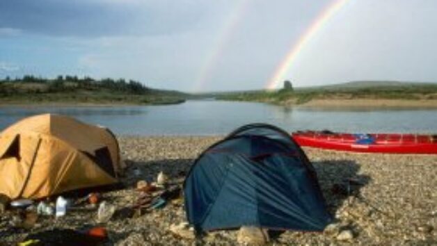
A double rainbow arched over the canyon that night as the walls opened and changed the character of the valley. Below Imo Falls, the largely Class I river featured excellent canoeing. The only tricky rapid was at Nedrefoss, which required sharp right-angle turns to avoid huge boulders and big wave trains. But when we slipped under a suspension bridge at the base of the rapid, the first real sign of accomodations for hikers, we glided into gentler current and a new phase in our river travel. Good thing, too. The preponderance of waterfalls for the next 18 miles would have been a safety hazard in more technically difficult rapids, since our eyes reached to the sky more than the river. Alv and Linda estimated that the river was almost three feet higher than normal, so we breezed along without following the normal tortuous course of the riverbed.
By mid-day we approached Mollis Falls, a huge column of water that spills off the ridge and drops 269 meters into a deep, green pool. It’s the tallest falls in northern Europe and the highest above the Arctic Circle, although Alv said many Canadians mistakenly believe Wilberforce Falls on the Hood River to have that distinction. It was the third time he had mentioned this bit of Canadian misinformation – clearly a bone of contention for this ordinarily easygoing man. Having stood on the edge of Wilberforce and the base of Mollis, I have to agree with the Norwegians, who take great pride in their country’s remarkable mountains. It’s clearly their honor to have the tallest falls.
Below Mollis where the river widens, our group decided to paddle late into the evening to reach the Elvestad homestead, where Alv’s mother Sofie had prepared a traditional fish-and-noodle casserole and her son cooked fresh cod steaks. Two days later, we paddled the remaining 20 miles of the river to Elvestad’s year-round home at Storslett, just on the edge of the Reisafjorden. Greenish water from glacier-fed streams flowed off steep cliffs reminiscent for me of the Nahanni and Miosie river canyons. To officially end the trip, we portaged the canoes through Einar’s hillside garden, past the potatoes, strawberries and colorful flowers, before celebrating with a fresh salmon dinner and the inevitable storytelling.
Later, from the front yard of the old homestead, I could see directly up the Josdalen – the Valley of the Scree – a steep side-canyon in the mountain range along the river. It was not a place to be during heavy snows in the winter, Alv had said, because of avalanche dangers. I had fleetingly thought about hiking up the ridge, about a 1,000-foot climb, in search of rare plants found in the alpine meadows. As a young boy Einar had played with Dag Hammarsjold, former Secretary General of the United Nations, when Dag’s father, a botanist, discovered the new species high on the ridge. But I abandoned the plan, comfortable in a wood chair by the front door and content with my view from the valley floor. I knew that leaving that hike as an idea rather than reality was likely to prompt a return. Having a little unfinished business with a special place – something to wonder about – is one of my favorite pastimes.
Laurie Gullion